


Langhei Twp. Voting District, Pope County, Minnesota
About
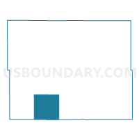
Outline

Summary
| Unique Area Identifier | 603759 |
| Name | Langhei Twp. Voting District |
| County | Pope County |
| State | Minnesota |
| Area (square miles) | 36.01 |
| Land Area (square miles) | 35.40 |
| Water Area (square miles) | 0.62 |
| % of Land Area | 98.29 |
| % of Water Area | 1.71 |
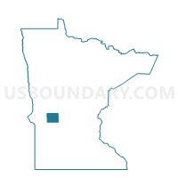
| Latitude of the Internal Point | 45.45389340 |
| Longtitude of the Internal Point | -95.57225410 |
Maps

Graphs
Select a template below for downloading or customizing gragh for Langhei Twp. Voting District, Pope County, Minnesota


Neighbors
Neighoring Voting District (by Name) Neighboring Voting District on the Map
- Barsness Twp. Voting District, Pope County, MN
- Benson Twp. Voting District, Swift County, MN
- Blue Mounds Twp. Voting District, Pope County, MN
- Camp Lake Twp. Voting District, Swift County, MN
- Clontarf Twp. Voting District, Swift County, MN
- Hoff Twp. Voting District, Pope County, MN
- Rolling Forks Twp. Voting District, Pope County, MN
- Walden Twp. Voting District, Pope County, MN
Top 10 Neighboring County Subdivision (by Population) Neighboring County Subdivision on the Map
- Benson township, Swift County, MN (334)
- Camp Lake township, Swift County, MN (213)
- Blue Mounds township, Pope County, MN (186)
- Langhei township, Pope County, MN (177)
- Walden township, Pope County, MN (169)
- Hoff township, Pope County, MN (152)
- Rolling Forks township, Pope County, MN (151)
- Barsness township, Pope County, MN (149)
- Clontarf township, Swift County, MN (86)
Top 10 Neighboring Unified School District (by Population) Neighboring Unified School District on the Map
- Minnewaska School District, MN (9,402)
- Benson Public School District, MN (5,684)
- Hancock Public School District, MN (1,305)